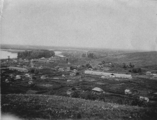
The photo of the Srostki village was taken by archaeologist Georgy Sosnovsky during the Biysk archaeological expedition in 1935-1936.
Sosnovsky finished a St Petersburg commercial school and graduated from Irkutsk University. During the expedition, he was employed at the State Academy of the History of Material Culture in Leningrad, and also worked part-time at the State Hermitage and the State Ethnographic Museum. He was particularly interested in the history of the Stone, Bronze and Iron Ages in Siberia.
In the photo, Sosnovsky captured a panorama of Baklan, the old part of Srostki, which opened from Mount Piket where ancient burial mounds were excavated. Residential houses and outbuildings alternate with spacious land plots. On the left, you can see the Katun River and a channel separating the village from the Popovsky Island, which got its name after the word pop (priest in Russian): a priest’s estate was located nearby.
Srostki was founded in 1804. Thanks to the natural landscape, the village had very comfortable living conditions: Mount Piket protected Srostki from the wind. The first official document that mentions the village is a population census of September 1811. It contains the history of the village: in 1804, 15 families moved from the village of Bolshaya Ugrenevaya to Srostki, as well as a family from Shubenskaya village. By 1811, 19 families with a total of 81 males lived in the village.
Shukshin wrote about his native village in a sketch: “… Probably, at first there were several small villages, and then, over time, they all grew together — into Srostki. On the other hand, the village became a melting pot of people with different traditions and dialects from the regions of Baklan, Nizovka, Mordva, Dikari and Golozhopka.” The people of Baklan were called chaldons — indigenous Russians in Eastern Siberia. They were tall and strong, they hunted and fished, so they knew the vicinity of the Katun River upstream and downstream. Their families did not have many children: women were industrious too and did a lot of work on a par with men.