In 1858 and 1860, thanks to the efforts of the statesman, military governor of Eastern Siberia Nikolay Nikolaevich Muravyov, the Russian Empire reclaimed the Amur Region and gained control of Primorye. Since that time, the resettlement of peasants from the central provinces of Russia to the deserted Far Eastern lands began in the country.
It took two years for the caravans with migrant peasants from the Perm, Tambov, Vyatka and Voronezh provinces to reach the settlement points. This way, in 1860, one of the first villages along the Amur River arose — the village of Permskoye. According to the rules of settlement, each peasant family was given a land allotment of 100 dessiatines (archaic land measurement used in tsarist Russia), that is, about 109 hectares. In the central part of Russia, families could get only 15 dessiatines. Such allotments in the Far East were allocated for several decades, but at the beginning of the 20th century, settlers began to receive the same amount of land as in other regions — 15 dessiatines per male soul.
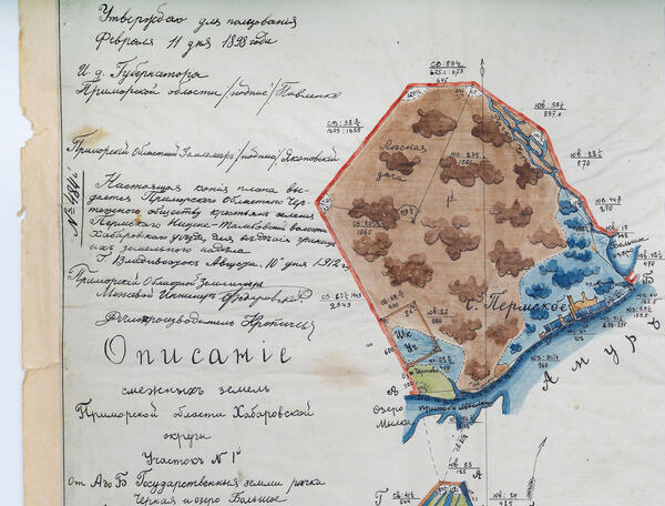
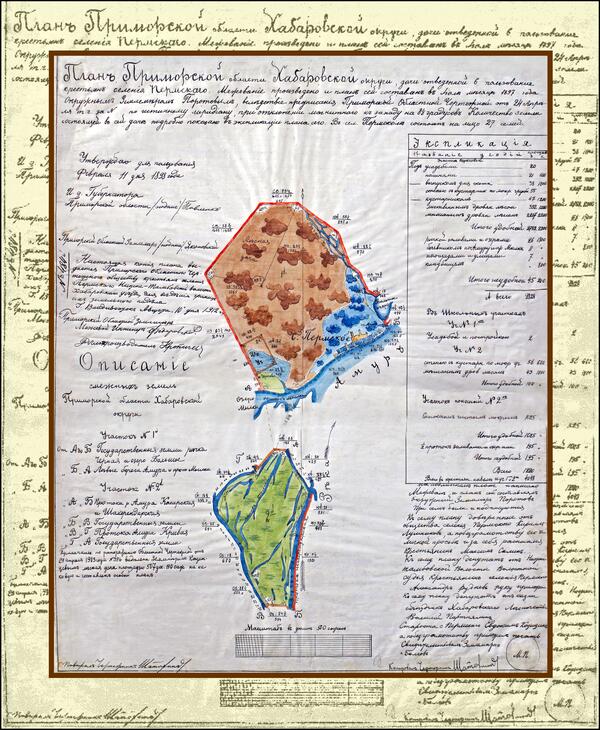
The name of the document is “The plan of the Primorsky region of the Khabarovsk district, of a cottage reserved for the use of the peasants of the Perm’s village. Land surveying was carried out and this plan was drawn up in July 1897 by the district surveyor Porotov” — this very name indicates the year of creation of the original and its author. The document recounts the first years of the development of the Amur lands.
The exhibit from the museum’s collection is a handwritten copy, which in 1912 the Primorsky Regional Drawing Office handed over to the rural community of Perm for the purpose of “maintaining the boundaries of their land plots.” The center of the document features an image of two land plots.
A graphic image of the
village was placed on Site No. 1, thanks to which it can be understood that
there was only one street in this area. It was located along the bank of the
Amur River. On April 24, 1897, the settlement consisted of 20 estates, which
housed 27 families. The “Explication” section on the right side of the document
reports that 20 estates occupied 20 versts, that is, about 21 kilometers, of
which “squares and streets” occupied 7 versts, the cemetery — 800 sazhens,
which is slightly more than 1.5 versts.