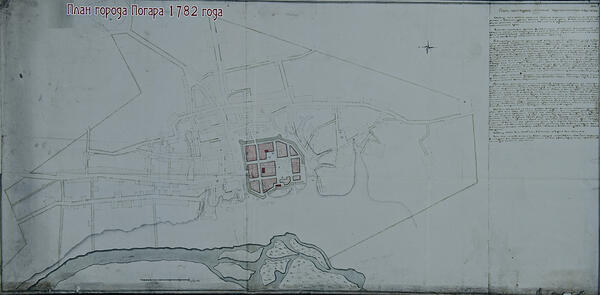
In the Radogoshch Museum, there is a copy of an ancient document — the plan of the town of Pogar of 1782. The original document is stored in the Russian State Historical Archive.
The first mention of the city can be dated back to 1155 when the village was called Radogoshch. However, invaders repeatedly burned down the city and that is how another name appeared — Pogar, which means “pogorely” (burnt down).
The museum houses a plan of the town of Pogar — it is divided into streets and neighborhoods. In the center of the city is the scheme of the fortress (its contours are highlighted in green). Inside the fortress, there are residential quarters. In addition, the map shows Zamkovaya Mountain — a fortification that belonged to the town’s owner, Polish commander and diplomat Alexander Pyasochinsky. Inside the fortress, there were the Nikolskaya church and the Assumption Cathedral, known since the mid-17th century. The plan also features the main streets of Pogar and shows a rampart, places where there were “brama” — watchtowers with gates, which were closed at night, and fortifications, which housed the artillery. During the construction of the fortress, the loopholes were given different names: Kryksa, Prozhiko, Korsakov, Kartavenko, Babichi. Many of them later became surnames for the Pogar soldiers.
The fortress was located in a place called Staraya Gorka. Podolnaya Street (the modern name of the street is Naberezhnaya) could be found near the main city gate, and it began at the ferry station and the milldam with the bridge. From the south, the fortress sided with Moskovskaya Street. Streets that went from Starodubskaya and Zarovskaya Towers were named after those towers. There were only two streets inside the fortress: Golodnaya and Oleynitskaya.
The plan also shows the churches that were located outside the fortress: the Holy Trinity Church, the St. Anna Church and the St. Athanasius Church.
The plan also reflects the local topography: hills, ravines, ditches, the Sudost River floodplain and a river meadow. According to the plan, in the 18th century, the river was full-flowing and had three channels at the foot of the fortress. The channels conflowed and formed six large islands. The city authorities used those islands for haymaking. Nowadays the Sudost River has only one channel.